Route summary, Map summary – Telenav for Sprint Supported Devices: v5.1 for Sanyo Katana; Motorola RAZR, KRZR User Manual
Page 30
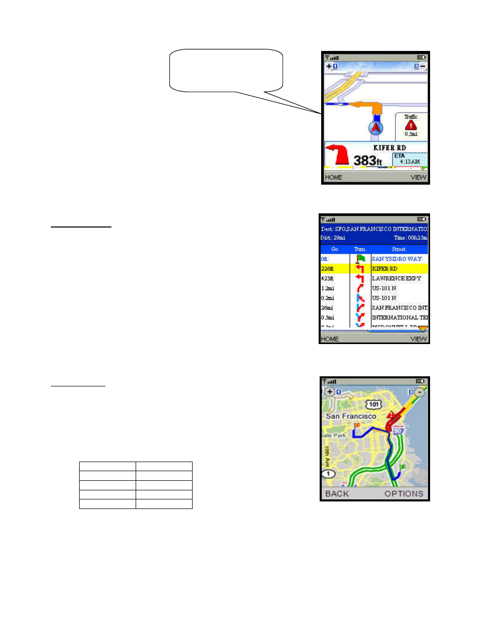
Route Summary
A text listing of every turn for this navigation session from your starting
location to your destination along with mini turn icons.
Map Summary
The entire route from your starting location to your destination is drawn on a
map, complete with the latest traffic alerts and traffic flow information. The
route is displayed as a blue line connecting the Start and Finish flags.
Highways and major roads with traffic flow information are color-coded by
speed in each direction of travel:
Speed Road
Color
> 50 mph
Green
30 – 50 mph
Yellow
< 30 mph
Red
Unknown Grey
1. Click the OPTIONS softkey to “Hide Traffic” or “Show Traffic”
(depends on availability).
2. Use the 1 and 3 number keys to zoom in and out of the map. Use
the navigation arrow keys to pan the map.
(Audio)
“Accident 2.3 miles ahead on
US 101 at Lawrence
Expressway; 1 lane closed.”
© TELENAV, INC. 2003-2006
PAGE 30 OF 54
- Scout v1.10 for iPhone (open market) (69 pages)
- Scout v1.9 for iPhone (open market) (70 pages)
- Scout v1.8 for iPhone (open market) (67 pages)
- Scout v1.7 for iPhone (open market) (65 pages)
- Scout v1.6 for iPhone (open market) (65 pages)
- Scout v1.5 for iPhone (open market) (120 pages)
- Scout v1.2 for iPhone (open market) (131 pages)
- Scout v1.1 for iPhone (open market) (129 pages)
- Scout v1.0 for iPhone (open market) (112 pages)
- Scout v1.4 for Android (75 pages)
- Scout v1.3 for Android (85 pages)
- Scout v1.2 for Android (87 pages)
- Scout v1.2 for Windows for T-Mobile (70 pages)
- Scout v1.0 for Windows for T-Mobile (74 pages)
- for Unlocked Supported Devices: v5.1 for HTC Advantage (6 pages)
- for Unlocked Supported Devices: Mobile Office - HTC Shift (136 pages)
- for Verizon Supported Devices: v6.2 for BlackBerry (64 pages)
- for Verizon Supported Devices: v6.2 for Android phones (57 pages)
- for Verizon Supported Devices: v5.5 for BlackBerry Storm (64 pages)
- for Verizon Supported Devices: v5.5 for BlackBerry Tour (68 pages)
- for Verizon Supported Devices: v5.1 for BlackBerry 8830 Users Guide (52 pages)
- for Verizon Supported Devices: v5.1 for BlackBerry 8830 Quick Start Guide (3 pages)
- for Verizon Supported Devices: v5.1 for BlackBerry Storm (56 pages)
- for Verizon Supported Devices: v5.1 for BlackBerry Tour (5 pages)
- for Verizon Supported Devices: v5.0 for Palm Treo 700p (43 pages)
- for Verizon Supported Devices: v4.1 for Palm Treo 650 (30 pages)
- for Verizon Supported Devices: v4.1 for Palm Treo 700w (29 pages)
- for Verizon Supported Devices: v4.1 for Verizon XV-6700 (31 pages)
- for T-Mobile Supported Devices: v7.1 for Android phones (94 pages)
- for T-Mobile Supported Devices: v6.2 for BlackBerry devices (69 pages)
- for T-Mobile Supported Devices: v6.2 for Android phones (61 pages)
- for T-Mobile Supported Devices: v6.0 for BlackBerry smartphones (58 pages)
- for T-Mobile Supported Devices: v5.8 for Android phones (71 pages)
- for Boost Mobile Supported Devices: v5.8 for BlackBerry smartphones (73 pages)
- for T-Mobile Supported Devices: v5.8 for Windows Phone 7 devices (66 pages)
- for T-Mobile Supported Devices: v5.76 for J2ME devices (71 pages)
- for T-Mobile Supported Devices: v5.5 for Windows Mobile HTC devices (64 pages)
- for T-Mobile Supported Devices: v5.5 for Windows Mobile smartphones (3 pages)
- for T-Mobile Supported Devices: v5.5 for Windows Mobile professional (4 pages)
- for T-Mobile Supported Devices: v5.5 for Android devices (71 pages)
- for T-Mobile Supported Devices: v5.5 for T-Mobile Sidekick LX (57 pages)
- for T-Mobile Supported Devices: v5.2 for J2ME touch screen devices (70 pages)
- for T-Mobile Supported Devices: v5.2 for Samsung T929 (69 pages)
- for T-Mobile Supported Devices: v5.2 for Samsung T919 Users Guide (60 pages)
- for T-Mobile Supported Devices: v5.2 for Samsung T919 Quick Start Guide (4 pages)