Operation, Speed and efficiency, Reliable, rugged & low cost design – Atec Geometrics-G-858 User Manual
Page 2: Applications
OPERATION
The G−858 MagMapper uses
a graphical interface to make
survey design and data
acquisition quick and
efficient. A "Simple" or
“Mapped” Mode uses line
numbers and known staked
reference points to define the
map parameters. Or the user
may use the integrated
Novatel Smart-V1™ GPS for
mapping positions
automatically. Position
information may come from
an external GPS, from
regularly spaced fiducial
marks input by the operator or
both. At any time, the user
may switch to “profile” mode
to observe the last 5 data lines
as stacked profiles.
Data is collected in up to 5
separate survey files and
transferred via high speed
RS−232 data link (or USB
with converter) to a computer
for further analysis and map
generation. The full featured
graphical data editing
program MagMap2000 is
provided to allow
repositioning, realignment, GPS
smoothing, data filtering and
interpolation of the data. After
editing, the data is formatted in
either Surfer for Windows or
Geosoft formats for further plotting
and analysis.
SPEED AND
EFFICIENCY
G−858 data acquisition offers
either continuous (automatic) or
discrete station recording. Data
quality is uniformly high and lower
costs are inherent for most projects
due to the high sampling rate of the
instrument in continuous mode.
This allows the operator to survey
an area at a fast pace, covering as
much as 10 times more area in a
given time period than other
magnetometers.
RELIABLE, RUGGED
& LOW COST DESIGN
In addition to its speed and
sensitivity, the G-858 is also
reliable, economical, and easy to
use. Electrical connectors on the
G-858’s sensor have been
eliminated in order to increase
reliability and reduce setup time.
The G-858’s internal firmware has
been streamlined to include those
features important for UXO,
archaeological, environmental,
utility, and mineral exploration. As
for economy - Contact Geometrics
for a quotation today! You’ll be
pleasantly surprised.
APPLICATIONS
The concentration of magnetic
minerals often varies with
geological formation or chemical
alteration and can indicate
hydrocarbon bearing structures
or economic mineral deposits. A
primary application of the G−858
MagMapper
is surveying for
utility lines, UXO’s,
archaeological, environmental,
and mineral projects. The G-858
is an excellent instrument for use
in academic research and
education and can also be used
for local environmental studies
such as mapping waste sites,
locating buried metal drums and
storage tanks buried pipelines,
well-heads and other sizable
ferrous structures.
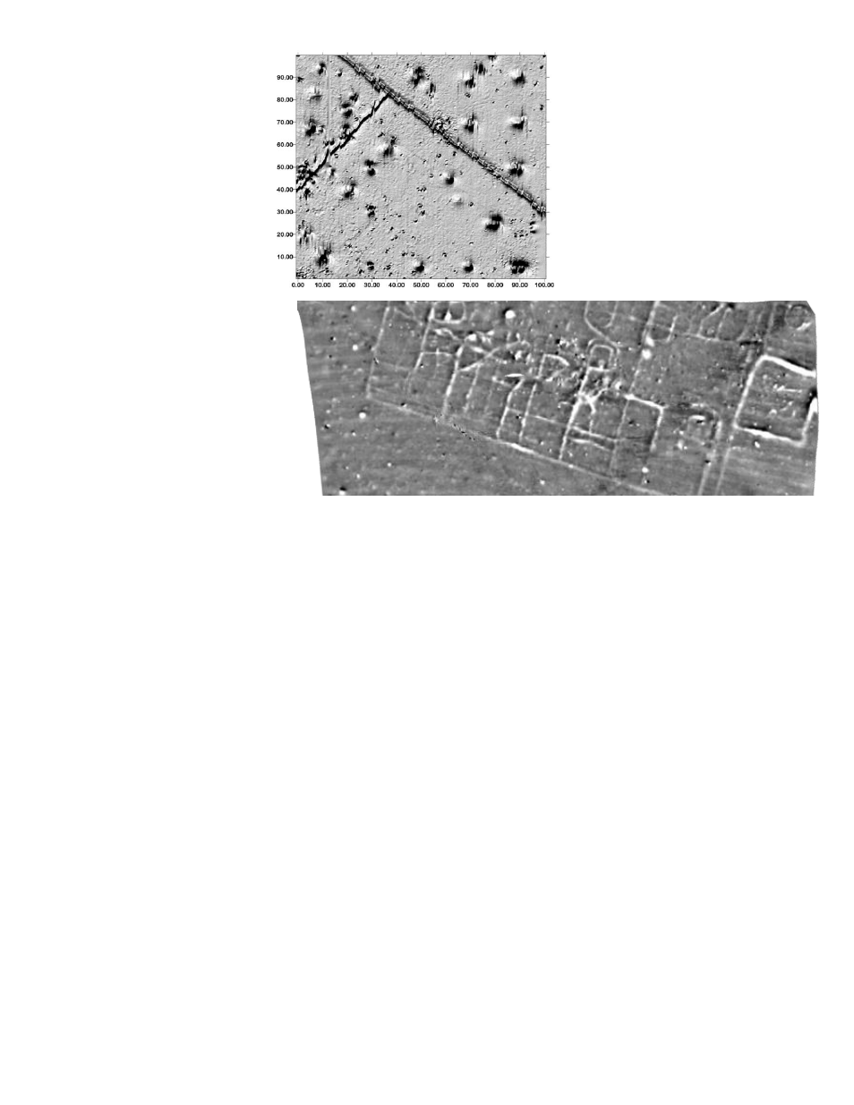
Stanford Metal Test Site and
Archaeological Survey Maps
The map on the left is data taken at a magnetometer test
site on Stanford University campus. Metallic objects of
different material, size, shape and weight were buried
throughout the 100 m x 100 m survey area at different
depths. Magnetic features were chosen to simulate
common environmental, engineering and UXO targets to be
able to characterize anomaly shapes and magnitudes.
This survey was conducted using a single sensor G-858
cesium magnetometer held on an aluminum staff at waist
height. Measurements were taken at 10 Hz at a normal
walking pace with lines separated by 2 m.
Photo credit to Geometrics, Inc with special thanks to
Stanford University for access to test site.
.
The map above is of a large Roman-era farm site in the English East Midlands, defined by ditch and pit fills and spreads of
magnetic soil and situated on fine grade till deposits over mudstone.
Plotted black -3.5 nT, white +3.5 nT from data collected using three G-858 magnetometers as dual magnetometers, with sensors
0.3m above the surface on a ATV-pulled sledge and coupled to ArchaeoPhysica's multi-instrument acquisition system exploiting
the real time RS232 data transfer from each magnetometer. Although the data is clear, subsequent excavation by archaeologists
revealed only the bases of features which highlighted the potential of magnetic survey for mapping otherwise poorly preserved
sites below arable fields.
Data courtesy of ArchaeoPhysica, with special thanks to Martin Roseveare for providing this image and information.