Finding longitude – DAVIS Mark 3 Sextant User Manual
Page 10
Page 8
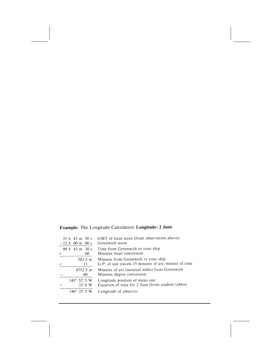
FINDING LONGITUDE
Meridians of longitude are measured east or west from the prime meridian (zero
degrees) at Greenwich, England. Because the ground position of the sun moves
around the earth at an average speed of 15° per hour (15 nautical miles per
minute), longitude may be calculated by comparing local noon with
Greenwich Mean Time. For example, if local noon occurred at 2:00 GMT, your
longitude is approximately 30° west of Greenwich (2 hours x 15° / hour = 30°).
To determine one’s exact position, the equation of time must be applied. The
earth in its orbit around the sun does not travel at a constant speed. Clocks and
watches, therefore, keep the time of a fictitious or mean sun which travels at the
same average speed throughout the year, and the position of the true sun (as
seen from the northern half of the earth) is not always due south or 180° true at
noon by the clock. The difference in time between the true sun and the mean sun
is call the “equation of time.” The equation of time for any given day may be found
in a Nautical Almanac; its approximate value may be found in the student tables at
the end of this booklet.
See figure 13 for a diagram based on this example.
meridian at 11:43:30 (exactly half the time between 11:23:30 and 12:03:30). Next,
you find the Greenwich Mean Time (GMT) of your local noon by listening to the
radio time signal, correcting any error your watch may have had. In this example,
you tune in the time signal and find that GMT is now 22:10:00. Your watch reads
12:10:00, so it has no error. You know that your local noon occurred at GMT
21:43:30 (26 minutes 30 seconds ago).
You now have enough facts to work out your noon sight: the date, the time of
meridian passage (local noon), the altitude of the sun at meridian passage, the
height of your eye above the surface of the sea, and the index error of the sextant
you are using.