Additional tools, Elevation plot – Garmin Oregon 400t User Manual
Page 25
Oregon Series Owner’s Manual
17
Additional Tools
Additional Tools
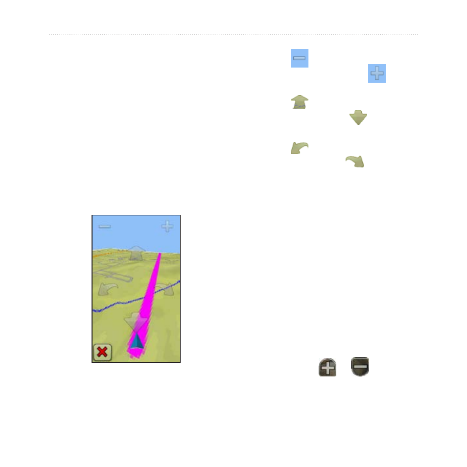
Using the 3D View
The Oregon 400t and 550t have a 3D
view. Other Oregon models require
DEM (digital elevation model) data
that can be found in some Garmin
topographic cartography. Go to
map products.
3D View
1. Touch
3D View
.
2. Touch
to increase the angle
of elevation, and touch
to
decrease the angle of elevation.
3. Touch
to pan the 3D map
forward, and touch
to pan the
3D map backward.
4. Touch
to rotate the view to
the left, and touch
to rotate
the view to the right.
Elevation Plot
The Oregon 300, 400t, 400c, 400i,
550 and 550t can record elevation
changes over distance or time, or
pressure (barometric or ambient)
changes over time. To set which
.
1. Touch
Elevation Plot
to open the
Elevation Plot page.
2. To adjust the distance or time
scale, touch
or
.
- nuvi 1490 (72 pages)
- eTrex Legend H (68 pages)
- eTrex Legend Cx (96 pages)
- Oregon 450 (8 pages)
- Oregon 450 (52 pages)
- GNS 430 (22 pages)
- GNS 430 (204 pages)
- GNS 430 (266 pages)
- GNS 430 (2 pages)
- Nuvi 265W (64 pages)
- nuvi 800 (76 pages)
- eTrex Legend (68 pages)
- GPSMAP 60CSx (2 pages)
- GPSMAP 60CSx (116 pages)
- Edge 800 (60 pages)
- Edge 800 (16 pages)
- Edge 500 (64 pages)
- Edge 500 (16 pages)
- GPS 12 (66 pages)
- GPSMAP 495 (179 pages)
- GPSMAP 196 (132 pages)
- GPS 190-01219-91 (36 pages)
- eTrex 190-00234-01 (2 pages)
- GPSMAP 7015 (132 pages)
- GPSMAP 190-00683-01 (2 pages)
- zumo 220LMT, Europe (58 pages)
- GPSMAP 7212 (2 pages)
- GPSMAP 76Cx (58 pages)
- 6000 (20 pages)
- GPSMAP 190-00683-00 (152 pages)
- Garmis GPS Smart Antenna GP35-HVS (41 pages)
- Zumo TM 500/550 (74 pages)
- 4010 (2 pages)
- 3000 (10 pages)
- GPSMAP 7215 (136 pages)
- GPSMAP 6208 (20 pages)
- GPSMAP 278 (138 pages)
- GPSMAP 278 (2 pages)
- ZUMO 400 EN (60 pages)
- zumo 450 (2 pages)
- zumo 450 (72 pages)
- 4000 Series (68 pages)
- ZUMO 65309R0 (6 pages)
- 398 (2 pages)
- GPSMAP 190-01155-02 (10 pages)