Driving to your destination, 2009 rdx, Map screen legend – Acura 2009 RDX Navigation User Manual
Page 54
54
Navigation System
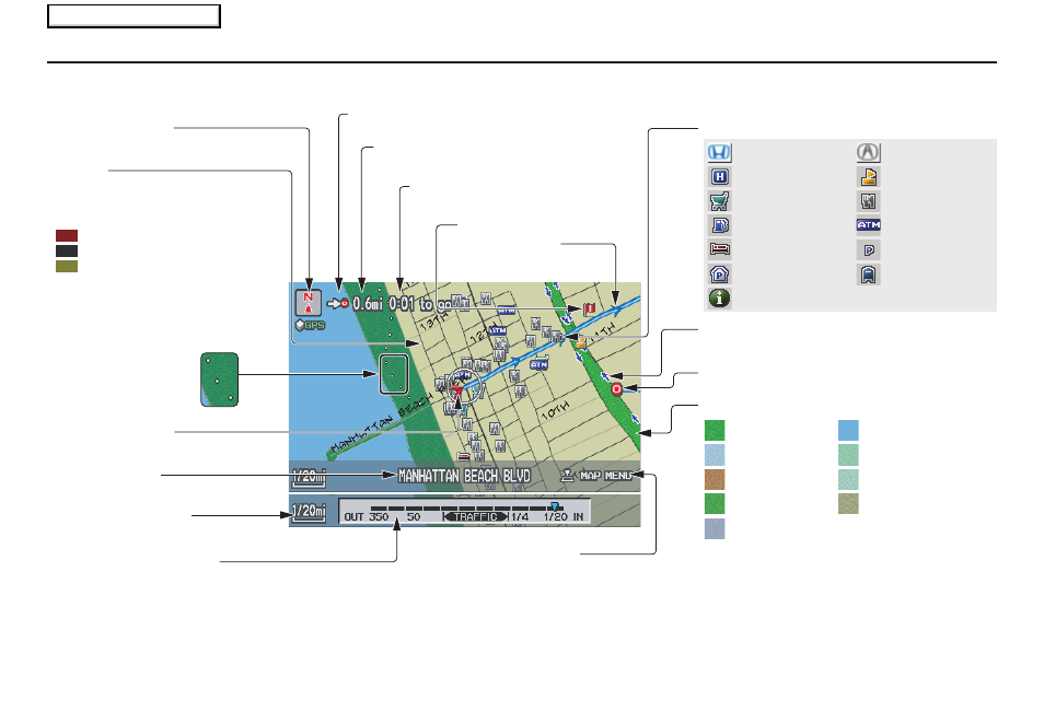
Map Screen Legend
Map Features
NOTE:
If you move the Interface Dial over an area (map
features shown above), the name is displayed on
the screen.
: Park
: Hospital
: Shopping Mall
: Golf Course
: Water Area
: Cemetery
: University
: Indian Reservation
: Airport/Stadium/Business
Acura Dealer
School
Restaurant
ATM
Parking Lot
Post Office
Honda Dealer
Hospital
Grocery Store
Gas Station
Hotel/Lodging
Parking Garage
Freeway Exit Information
Landmark Icon - Generic (see page
62
)
Destination Icon (see page
61
)
Map Scale Adjustment
(Mile or km per half-inch appears
only when you zoom in or out by
rotating the Interface Dial knob.)
(see page
60
)
NOTE:
See
Map Legend on the Information screen for further explanation (see page
80
).
Current Map Scale
(see page
60
)
Current Street
(see page
6
)
Vehicle Position
(see page
68
)
“Breadcrumbs”
(see Off-road
Tracking on page
67
)
Streets
(see Map Overview on page
6
, or
Unverified Area Routing on
page
92
)
Interstates or Freeways
Verified Streets
Unverified Streets
Direction of Destination (when en route)
(see page
56
)
Map Orientation
(see page
61
)
Distance to Destination
(see page
56
)
Time to Destination
(see page
56
)
Waypoint (see page
71
)
Blue Line
Calculated route
(see page
53
)
Map Menu (see page
56
)
(Push in on the Interface Dial to view.)
One-Way Traffic Icon (1/20 mile scale
only) (see page
62
)
Driving to Your Destination
2009 RDX
Main Menu