Map scale -11 – NISSAN 2008 NAVIGATION SYSTEM User Manual
Page 45
Black plate (47,1)
Model "NAV2-N" EDITED: 2007/ 3/ 9
INFO:
Free zoom:
Once the Free Zoom is set in the setting screen,
the scale can be changed in smaller steps when
you push and hold [ZOOM IN] or [ZOOM OUT]
than when you briefly push the button.
If you briefly push the button, the operation
returns to normal.
Setting by voice command
1. Push
switch.
2. After the tone sounds, speak a command.
To change the map scale:
“Zoom In”
“Zoom Out”
“<
1, 2, 5, 8, 32, 400> mile Scale”
“<
1/8, 1/4, 1/2> mile Scale”
“<
150, 300> feet Scale”
“<
75, 150> feet Building Scale”
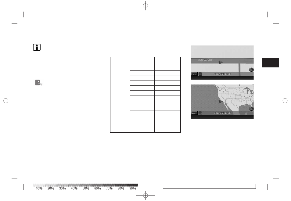
MAP SCALE
The following scales are available depending on
the map view.
. In Plan View:
Widest (1/51,200,000) to the most detailed
(1/2,500)
. In Birdview
TM
:
Widest (1/20,480,000) to the most detailed
(viewpoint height at 1/3,000)
Scale level of the Plan View display
Map scale
Actual distance
Normal Map
1:51.2 million
400 miles
(640 km)
1:5.12 million 32 miles (64 km)
1:1.28 million
8 miles (16 km)
1:800,000
5 miles (10 km)
1:320,000
2 miles (4 km)
1:160,000
1 mile (2 km)
1:80,000
1/2 mile (1 km)
1:40,000 1/4 mile (500 m)
1:20,000 1/8 mile (200 m)
1:10,000
300 ft (100 m)
1:5,000
150 ft (50 m)
Building
footprint
graphics
1:5,000
150 ft (50 m)
1:2,500
75 ft (25 m)
Example: The most detailed level
Example: The widest level
Map settings
3-11