Measuring distance – Garmin GPSMAP 278 User Manual
Page 56
Measuring Distance
You can measure the distance and bearing between two map items.
To measure the bearing/distance between two points:
1. On the Map Page, press
MENU to open the options menu.
2. Highlight
Measure Distance, and press ENTER. An
on-screen arrow appears on the map at your present location
with
ENT REF below it.
3. Move the arrow to the reference point (the starting point that
you want to measure from), and press
ENTER. A push pin
icon marks the starting point.
4. Move the arrow to the point want to measure to. The bearing
and distance from the reference point and arrow coordinates
appear in the data window at the top of the display.
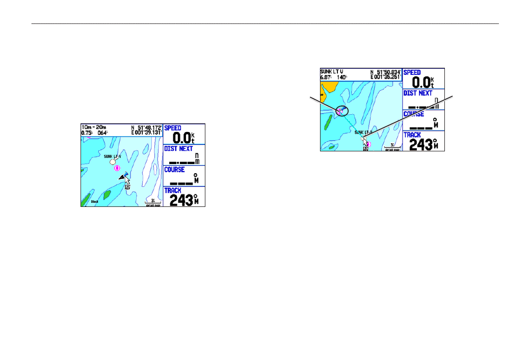
Measure Distance
End point of
measurement,
labeled
ENT REF
Push pin
indicating the
beginning
point of the
measurement
5. Press
QUIT to finish.
8
GPSMAP 278 Owner’s Manual
M
ArIne
M
ode
P
Ages
>
M
AP
P
Age
- nuvi 1490 (72 pages)
- eTrex Legend H (68 pages)
- eTrex Legend Cx (96 pages)
- Oregon 450 (52 pages)
- Oregon 450 (8 pages)
- GNS 430 (2 pages)
- GNS 430 (22 pages)
- GNS 430 (204 pages)
- GNS 430 (266 pages)
- Nuvi 265W (64 pages)
- nuvi 800 (76 pages)
- eTrex Legend (68 pages)
- GPSMAP 60CSx (2 pages)
- GPSMAP 60CSx (116 pages)
- Edge 800 (60 pages)
- Edge 800 (16 pages)
- Edge 500 (64 pages)
- Edge 500 (16 pages)
- GPS 12 (66 pages)
- GPSMAP 495 (179 pages)
- GPSMAP 196 (132 pages)
- GPS 190-01219-91 (36 pages)
- eTrex 190-00234-01 (2 pages)
- GPSMAP 7015 (132 pages)
- GPSMAP 190-00683-01 (2 pages)
- zumo 220LMT, Europe (58 pages)
- GPSMAP 7212 (2 pages)
- GPSMAP 76Cx (58 pages)
- 6000 (20 pages)
- GPSMAP 190-00683-00 (152 pages)
- Garmis GPS Smart Antenna GP35-HVS (41 pages)
- Zumo TM 500/550 (74 pages)
- 4010 (2 pages)
- 3000 (10 pages)
- GPSMAP 7215 (136 pages)
- GPSMAP 6208 (20 pages)
- GPSMAP 278 (2 pages)
- zumo 450 (72 pages)
- ZUMO 400 EN (60 pages)
- zumo 450 (2 pages)
- 4000 Series (68 pages)
- ZUMO 65309R0 (6 pages)
- 398 (2 pages)
- GPSMAP 190-01155-02 (10 pages)