Weather display calibration, Theory of operation weather display calibration – BendixKing IN-182A System RDR-2000 User Manual
Page 18
14
Effective Date: 5/98
RDR 2000 Pilot's Guide: Rev 3
Theory of Operation
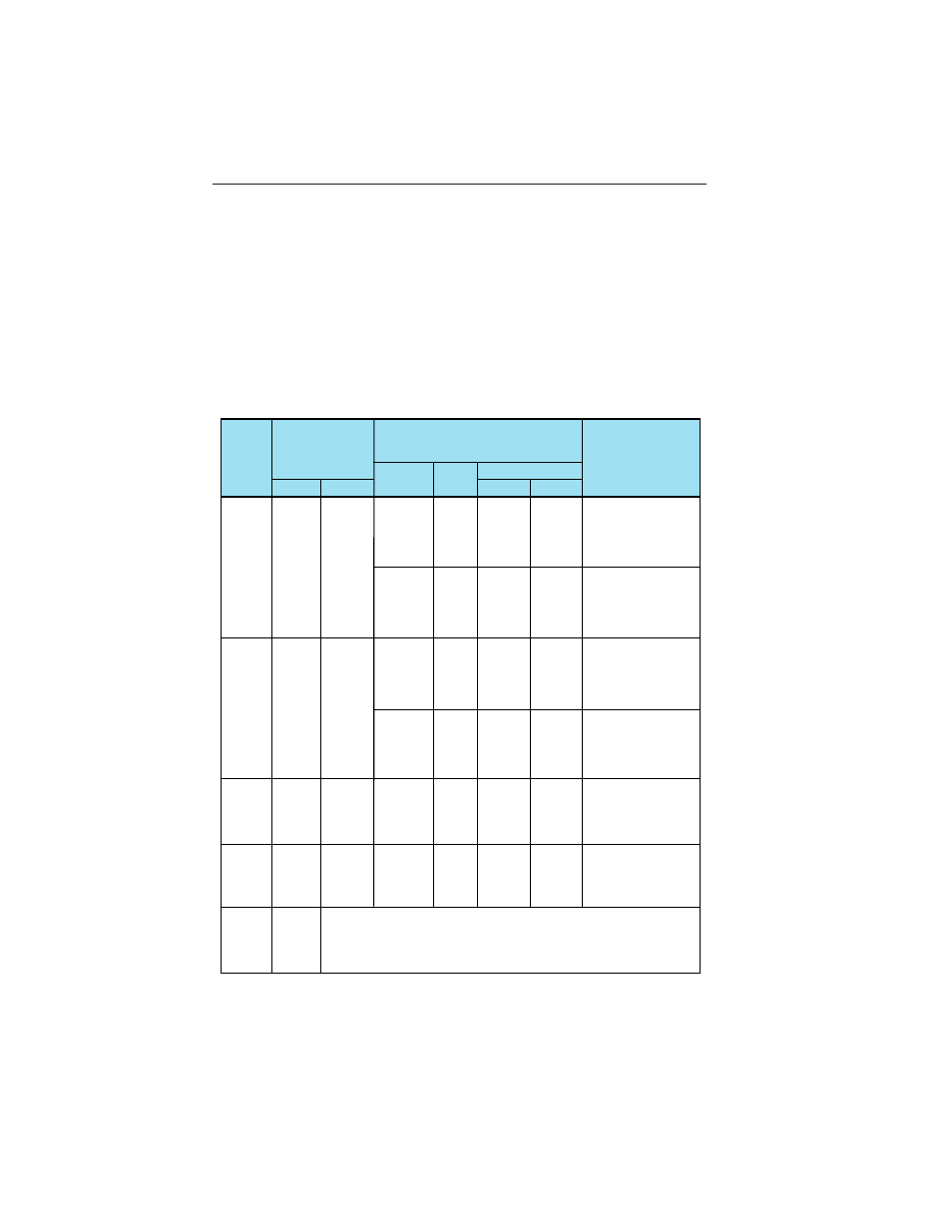
WEATHER DISPLAY CALIBRATION
The radar display has been calibrated to show five levels of target inten-
sity: Black (level 0), Green (level 1), Yellow (level 2), Red (level 3), and
Magenta (level 4). The meaning of these levels is shown in the following
chart as to their approximate relationship to the Video Integration
Processor (VIP) intensity levels used by the National Weather Service.
These levels are valid only when; (1) the Wx and WxA mode are
selected; (2) the displayed returns are within the STC range of the radar
(approximately 40 miles); (3) the returns are beam filling; (4) there are no
intervening radar returns.
Display
Level
Greater
Than
50
mm/Hr.
4
(Magenta)
In./Hr.
In./Hr.
mm/Hr.
Rainfall Rate
VIP
Level
Storm
Category
Remarks
Video Integrated Processor (VIP)
Categorizations
Rainfall Rate
Severe turbulence,
large hail, lightning,
extensive wind gust,
and turbulence.
5
Greater
Than
125
6
Extreme
Greater
Than
2
Severe turbulence,
lightning,organized
wind gusts, hail
likely.
2-5
50-125
5
Intense
Severe turbulence
likely, lightning.
1-2
25-50
4
Very
Strong
Severe turbulence,
possible lightning.
0.5-1
12-25
3
Strong
Light to moderate
turbulence is
possible with
lightning.
0.1-0.5
2.5-12
2
Moderate
Light to moderate
turbulence is
possible with
lightning.
.01-0.1
0.25-2.5
1
Weak
12-50
3
(Red)
0.5-2
4-12
2
(Yellow)
0.17-0.5
1-4
1
(Green)
0.04-0.17
Less
Than
1
0
(Black)
Less
Than
0.04
Radar Display and Thunderstorm Levels
Versus Rainfall Rates