Using the flasher screen, Understanding the flasher screen – Garmin 190-00864-01 User Manual
Page 10
Fishfinder 300C Quick Start Manual
Understanding the Flasher
Screen
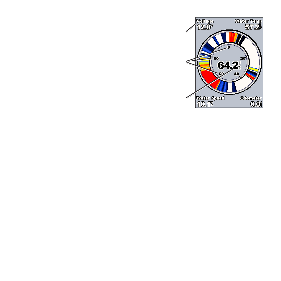
From the Home screen, select
Flasher
to
display sonar information on a circular depth
scale. The scale indicates what is beneath
your boat. It is organized as a ring that starts
at the top and progresses clockwise. Sonar
information flashes on the ring when it is
received at the depth indicated. The colors
indicate different strengths of the sonar
return. (When using the white default color
scheme, red indicates the strongest return,
blue indicates the weakest return, and white
indicates no return.)
Battery voltage
Water depth at
current location
Depth of sonar
readings
Press
MENU
to change the range, gain,
beam, and sonar settings, as described
starting on
.
See also other documents in the category Garmin Sports and recreation:
- GMR 406 (26 pages)
- 340c (2 pages)
- GHP 10 (48 pages)
- GMR 1204 (14 pages)
- GMR24 Hd (12 pages)
- GFS 10 (24 pages)
- GMR 40 (32 pages)
- GMI 10 (8 pages)
- GMI 10 (20 pages)
- 240 (50 pages)
- Hiking Equipment (2 pages)
- GHS 10i (10 pages)
- G2 (24 pages)
- 100 BLUE (50 pages)
- GSD-20 (12 pages)
- GTX 320 ATC (24 pages)
- 80 (2 pages)
- GMR 41 (32 pages)
- 160 BLUE (50 pages)
- 250C (1 page)
- VHF 200 (10 pages)
- GPSMAP 2008 (124 pages)
- GMR 41 (26 pages)
- 160 (50 pages)
- Gxm 51 (10 pages)
- 160C (32 pages)
- Nuvi 900 (16 pages)
- GSD22 (8 pages)
- 90/140 (32 pages)
- VHF 200 (2 pages)
- Ghc 10 (28 pages)
- GSD 22 (10 pages)
- GPSMAP 3010C (2 pages)
- GPSMAP 3010C (130 pages)
- GPSMAP 76CSx (64 pages)
- GPSMAP 76CSx (2 pages)
- GPSMAP 76S (76 pages)
- GPSMAP 76S (18 pages)
- GPSMAP 172C (110 pages)
- GPSMAP 3005C (124 pages)
- GPSMAP 3005C (2 pages)
- GPSMAP 276C (2 pages)
- GTX 328 (10 pages)
- GPSMAP 526s (84 pages)