Driving to your destination, 2009 tl, Map scale – Acura 2009 TL Navigation User Manual
Page 62
Driving to Your Destination
62
Navigation System
Map Scale
Rotate the
Interface Dial knob
or a voice command such as “Display 1/2 mile scale” (see page
157
)
to change the scale of the
map. Zooming in increases the detail, while zooming out gives you a view of a wider area. After changing the scale, give the
system a few moments to update the display.
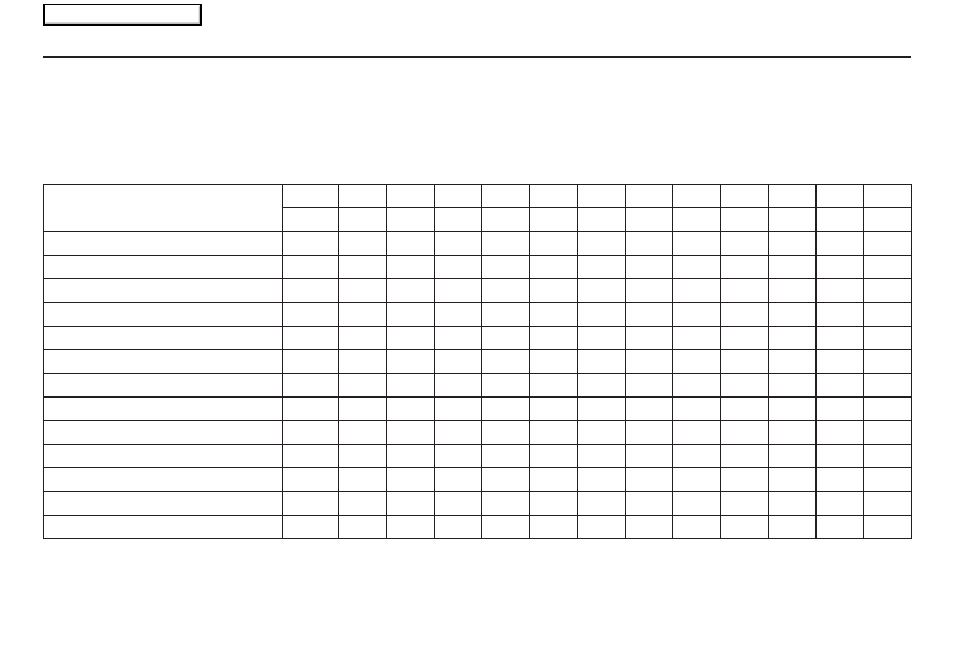
Functions available at various map scales
Map Scale (English and Metric) For
selecting units, see page
102
.
1/20mi. 1/8 mi. 1/4 mi. 1/2 mi.
1 mi.
2 mi.
5 mi.
15 mi.
50 mi. 150 mi. 350 mi. 1000 mi.
80 m 200 m 400 m 800 m 1.6 km 3 km
8 km 24 km 80 km 240 km 560 km 1600 km
POI icon symbols (like ATM)
page
64
X
X
Breadcrumbs (off-road tracking dots) page
70
X
X
X
X
Freeway exit information icons
page
64
X
X
X
One-way traffi c icon
page
64
X
Unverifi ed road display (purple)
page
6
X
X
X
X
X
X
X
X
Map orientation “Heading up”
page
63
X
X
X
X
X
Map orientation “North up”
page
63
X
X
X
X
X
X
X
X
X
X
X
X
Map features (park, golf course)
page
56
X
X
X
X
X
X
X
X
X
X
X
Avoid area shown on map
page
107
X
X
X
Avoid area scales (when creating)
page
107
X
X
X
Waypoint “fl ag” icons
page
75
X
X
X
X
X
X
X
X
X
X
X
X
Traffi c speed / incident
page
22
X
X
X
X
X
X
X
Weather information
page
81
X
X
X
X
X
X
X
X
X
X
X
X
NOTE:
• You can change between miles or kilometers in
SETUP
(see Units on page
102
).
• For information on the available voice commands, see Voice Command Index on page
156
.
2009 TL
Main Menu