Viewing tide and current information – Garmin G2 User Manual
Page 17
BlueChart g2 User’s Guide
v
IewIng
b
lue
c
hart
g
2 >
v
IewIng
t
Ide
and
c
urrent
I
nformatIon
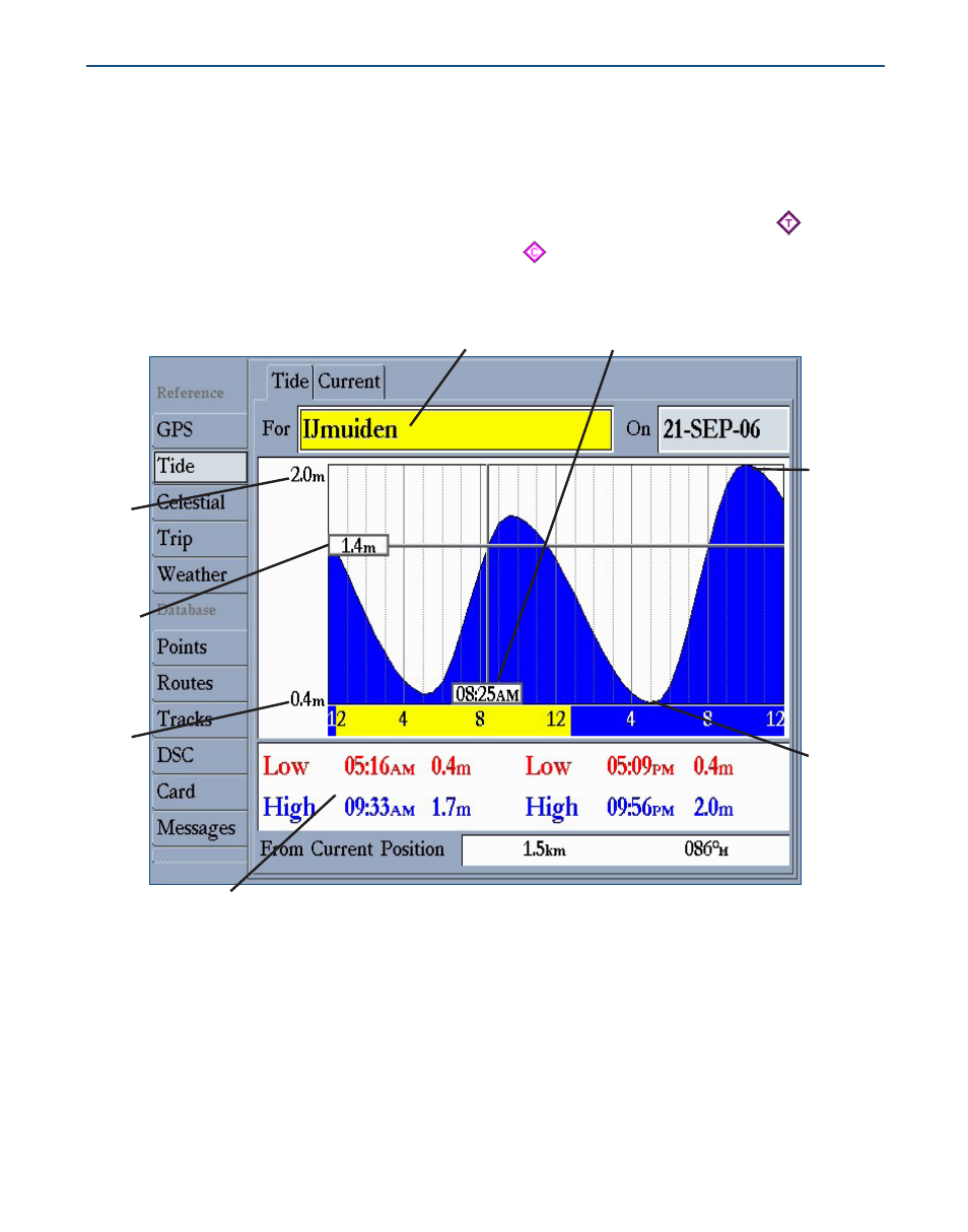
Viewing Tide and Current Information
Using BlueChart g2 cartography, you can access tide information from more than 3,000 Tide
Prediction Stations across the world. You can also access current information from Current
Stations around the United States coastline, including Alaska and Hawaii as well as western
Canada and several Caribbean islands. Tide Prediction Stations are denoted with a icon on
the Map Page; Current Stations are indicated with a icon.
Tide station
Event times
Min.
level
Max.
level
Local time
High
tide
curve
Low tide
curve
Tide
height
See your chartplotter’s owner’s manual for compatibility and instructions on viewing tide and
current information on your Garmin unit.
- GMR 406 (26 pages)
- 340c (2 pages)
- GHP 10 (48 pages)
- GMR 1204 (14 pages)
- GMR24 Hd (12 pages)
- 190-00864-01 (24 pages)
- GFS 10 (24 pages)
- GMR 40 (32 pages)
- GMI 10 (8 pages)
- GMI 10 (20 pages)
- 240 (50 pages)
- Hiking Equipment (2 pages)
- GHS 10i (10 pages)
- 100 BLUE (50 pages)
- GSD-20 (12 pages)
- GTX 320 ATC (24 pages)
- 80 (2 pages)
- GMR 41 (32 pages)
- 160 BLUE (50 pages)
- 250C (1 page)
- VHF 200 (10 pages)
- GPSMAP 2008 (124 pages)
- GMR 41 (26 pages)
- 160 (50 pages)
- Gxm 51 (10 pages)
- 160C (32 pages)
- Nuvi 900 (16 pages)
- GSD22 (8 pages)
- 90/140 (32 pages)
- VHF 200 (2 pages)
- Ghc 10 (28 pages)
- GSD 22 (10 pages)
- GPSMAP 3010C (130 pages)
- GPSMAP 3010C (2 pages)
- GPSMAP 76CSx (64 pages)
- GPSMAP 76CSx (2 pages)
- GPSMAP 76S (76 pages)
- GPSMAP 76S (18 pages)
- GPSMAP 172C (110 pages)
- GPSMAP 3005C (124 pages)
- GPSMAP 3005C (2 pages)
- GPSMAP 276C (2 pages)
- GTX 328 (10 pages)
- GPSMAP 526s (84 pages)