GLOBALSAT ET-314 GPS Engine Board User Manual
Page 12
ET-314AC
High Performance GPS Engine Board
2010/4/1
- 12 -
SNR(C/No)
42
dBHz
Range 0 to 99,null when not tracking
Checksum *71
End of message termination
1. Depending on the number of satellites tracked, multiple messages of GSV data may be
required. In some software versions, the maximum number of satellites reported as visible is
limited to 12, even though more may be visible.
RMC - Recommended Minimum Specific GNSS Data
Note – Fields marked in italic
red
apply only to NMEA version 2.3 (and later) in this NMEA
message description
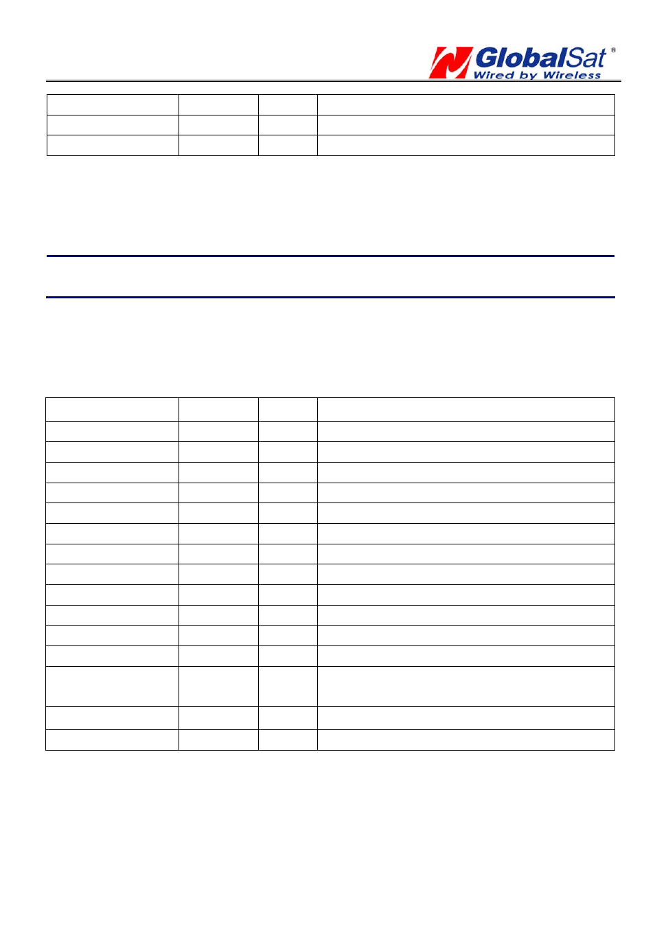
Table A-6 contains the values for the following example:
$GPRMC,161229.487,A,3723.2475,N,12158.3416,W,0.13,309.62,120598,,*10
Table A-6 RMC Data Format
Name Example
Units
Description
Message ID
$GPRMC
RMC protocol header
UTC Time
161229.487
hhmmss.sss
Status
1
A
A=data valid or V=data not valid
Latitude
3723.2475
ddmm.mmmm
N/S Indicator
N
N=north or S=south
Longitude 12158.3416
dddmm.mmmm
E/W Indicator
W
E=east or W=west
Speed Over Ground 0.13
knots
Course Over Ground 309.62
degrees True
Date
120598
ddmmyy
Magnetic Variation
2
degrees E=east
or
W=west
East/West Indicator
2
E
E=east
Mode
A
A=Autonomous, D=DGPS, E=DR
N=Output Data Not Valid
Checksum *10
End of message termination
1. A valid status is derived from all the parameters set in the software. This includes the
minimum number of satellites required, any DOP mask setting, presence of DGPS
corrections, etc. If the default or current software setting requires that a factor is met, then if
that factor is not met the solution will be marked as invalid.
2. SiRF Technology Inc. does not support magnetic declination. All “course over ground” data