Spectra Precision Ranger 3 User Manual
Page 5
Setup
Survey Pro setup routines are designed to
get you working as soon as possible.
Multiple instrument setup options using
known points or resection means you can
work the way you need to work. Results
are conveniently displayed making
it easy to check the setup. All setup data is
stored and is easily reviewed and edited
as necessary using the integrated data
editor. If an instrument height is updated,
all affected coordinates will also be
updated. Survey Pro puts you in control.
GNSS Setup
Survey Pro provides two main methods
of configuring a GNSS survey: Mapping
Plane and Calibration. With these two
methods, there is nearly infinite flexibility.
Calibration allows you to use a local
coordinate system, often set using total
stations. This keeps everything aligned
which makes you more productive.
Survey Pro walks you through the process
and provides check routines to ensure
everything is spot on.
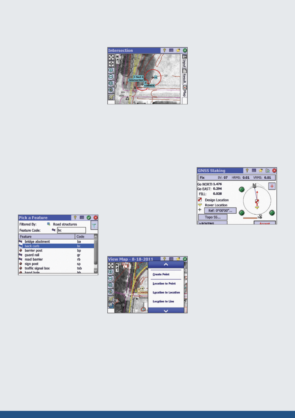
Feature and Attribute
collection
You can define features like “utility pole”
and “water line” using feature codes in
the field or in the office. Add features and
attributes as you survey. Using line
features, Survey Pro will automatically
draw lines in real time making it easy tto
verify your work before leaving the job site.
Process and adjust the data in Spectra
Precision Survey Office and export to
common data formats when you are done.
COGO, Inverse, and Curves
Survey Pro software provides powerful
Coordinate Geometry (COGO), Inverse
and Curve functions. Survey Pro offers a
full suite of COGO functions, enabling
you to easily perform calculations between
a known and new point, compute offset,
lines, alignments and points. Survey Pro
inverse functions allow you to quickly
inverse to points, lines, polylines,
and alignments, making it easy to verify
point locations and offsets from existing as
staked features or linework created on the
data collector.
The Survey Pro Curve menu contains
powerful curve functions that compute
and display all elements of horizontal
circular curves, spirals or vertical parabolic
curves. It then provides the most common
methods to help you layout the curve in
the field.
Active Maps
Seeing your data graphically helps
speed your work and ensures there are
no mistakes. Survey Pro provides several
exciting map features for just this reason.
Active Maps provide a way to do
calculations or initiate measurements right
from the map views. Tap on a point to
stake it. Tap two points to compute the
inverse. Or, enter Survey Mode and collect
points seeing them appear on the map as
they are measured. Active Background
Maps provide a method of importing DXF
files that can be used for calculations or
staking. Select a DXF line and offset points
or stake it. You have full control of the DXF
file layers; hide them, show them, or freeze
them. See what you need to see, how you
need to see it.
Stakeout
Survey Pro provides tools to complete your
stakeout tasks more efficiently. Using an
active map view or interactive features,
Survey Pro navigates you to the points you
need to stake, when you need to stake
them. Points are checked off as they are
staked, preventing you from duplicating
observations.
Survey Pro stores all measurement data
and any as-built or as staked points that
are collected. This data can then be used
for cut sheet reports in the office either
using Spectra Precision Survey Office or
XML Style sheets. Stake DTM surfaces
and use the data collected to compute
volumes in the field. View the resultant
DTM being staked in the field to
determine where additional points might
be needed. Survey Pro displays cut / fill
information for any location on the DTM
surface in real-time.