A message, Getting started, 2010 tsx – Acura 2010 TSX Navigation User Manual
Page 19: Map screen legend
Navigation System
19
Getting Started
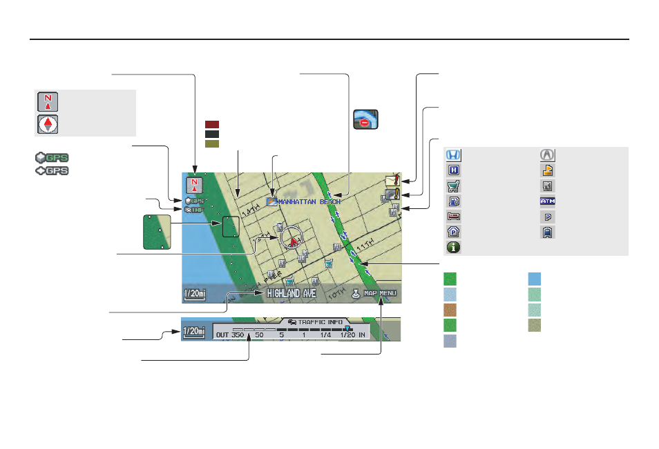
Map Screen Legend
Acura Dealer
School
Restaurant
ATM
Parking Lot
Post Office
Honda Dealer
Hospital
Grocery Store
Gas Station
Hotel/Lodging
Parking Garage
Freeway Exit Information
Vehicle Position
(see page
(Use voice command
“Display the current location,” or
use the Interface Dial to show
current location.)
Landmark Icon - Generic (see page
)
Current Map Scale
(see page
Map Features
NOTE:
If you move the Interface Dial over an
area (map features shown above), the
name is displayed on the screen.
: Park
: Hospital
: Shopping Mall
: Golf Course
: Water Area
: Cemetery
: University
: Indian Reservation
: Airport/Stadium/Business
Current Street
(see page
NOTE:
See
Map Legend
on the
INFO
screen (
Other
) for further explanation.
GPS Signal Strength
: Best Reception
: Good Reception
Missing: Poor/No Reception
“North Up”
“Heading Up”
Map Orientation
(see page
)
Map Menu
(see page
(Push in on the Interface Dial to view.)
Map Scale Adjustment
(Mile or km per half-inch appears only when you
zoom in or out by rotating the Interface Dial knob.)
Traffic Status Indicator
(see page
Breadcrumbs
(see
Off-road Tracking
on page 69)
Weather Icon
(see page
One-Way Traffic Icon
(1/20 mile scale only) (see
page
63
)
Message Icon (see page
Indicates that you have a message. View
messages by pushing in on the Interface Dial.
Warning Icon
Indicates that there are weather warnings.
To check the warning list, see page
.
Streets
(see
Map Overview
on page
Interstates or Freeways
Verified Streets
Unverified Streets
No Entry Icon
2010 TSX