Getting started, 2009 tsx, Map screen legend – Acura 2009 TSX Navigation User Manual
Page 19
Navigation System
19
Getting Started
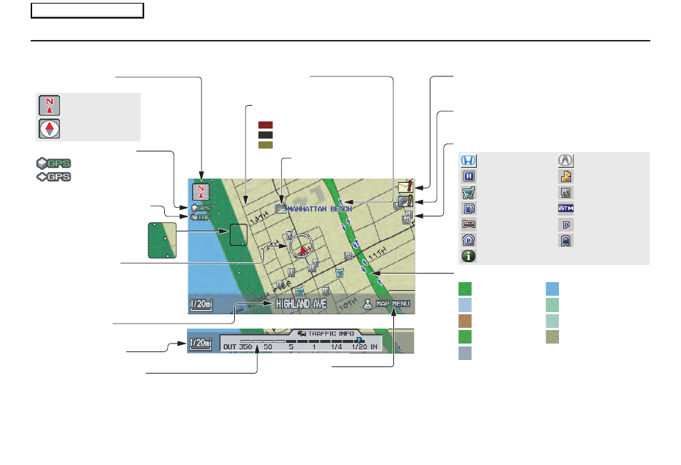
Map Screen Legend
Acura Dealer
School
Restaurant
ATM
Parking Lot
Post Office
Honda Dealer
Hospital
Grocery Store
Gas Station
Hotel/Lodging
Parking Garage
Freeway Exit Information
Vehicle Position
(see page
70
)
(Use voice command
“Display the current location,” or
use the Interface Dial to show
current location.)
Landmark Icon - Generic (see page
63
)
Current Map Scale
(see page
61
)
Map Features
NOTE:
If you move the Interface Dial over an
area (map features shown above), the
name is displayed on the screen.
: Park
: Hospital
: Shopping Mall
: Golf Course
: Water Area
: Cemetery
: University
: Indian Reservation
: Airport/Stadium/Business
Current Street
(see page
6
)
NOTE:
See
Map Legend
on the
INFO
screen (
Other
) for further explanation.
GPS Signal Strength
: Best Reception
: Good Reception
Missing: Poor/No Reception
“North Up”
“Heading Up”
Map Orientation
(see page
62
)
Map Menu
(see page
57
)
(Push in on the Interface Dial to view.)
Map Scale Adjustment
(Mile or km per half-inch appears only when you
zoom in or out by rotating the Interface Dial knob.)
Traffic Status Indicator
(see page
22
)
“Breadcrumbs”
(see Off-road Tracking
on page
69
)
Weather Icon
(see page
64
)
One-Way Traffic Icon
(1/20 mile scale only) (see page
63
)
Message Icon (see page
78
)
Indicates that you have a message. View
messages by pushing in on the Interface Dial.
Warning Icon
Indicates that there are weather warnings.
To check the warning list, see page
82
.
Streets
(see Map Overview on page
6
)
Interstates or Freeways
Verified Streets
Unverified Streets
2009 TSX
Main Menu