IBM G- MR G-Mouse GPS Receiver G-Mouse MR User Manual
Page 14
G-Mouse GPS Receiver User Manual
Page 13
$GPGSV,2,1,07,07,79,048,42,02,51,062,43,26,36,256,42,27,27,138,42*71
$GPGSV,2,2,07,09,23,313,42,04,19,159,41,15,12,041,42*41
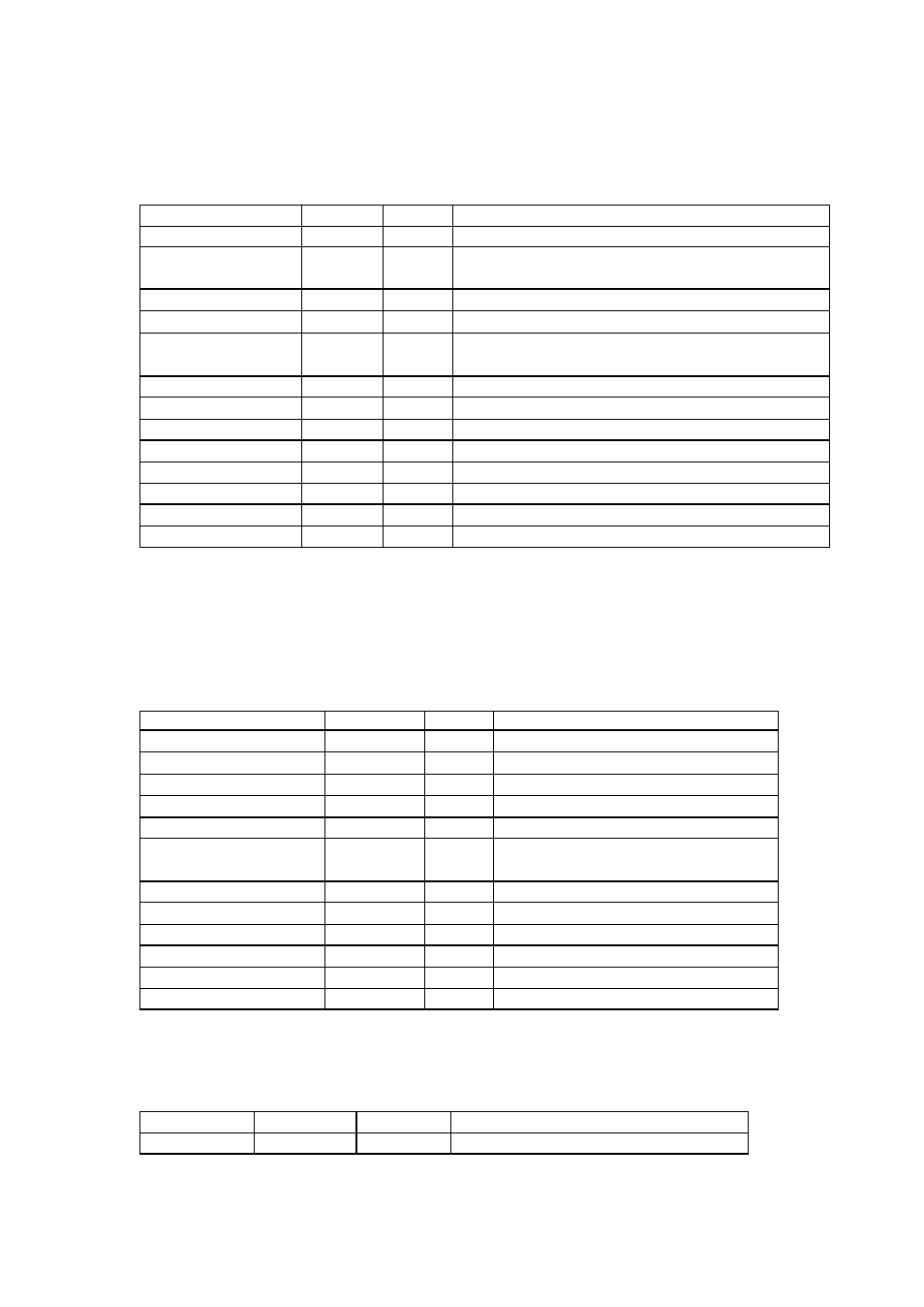
Table A-8 GSV Data Format
Name
Example Units
Description
Message ID
$GPGSV
GSV protocol header
Number of
Messages1
2
Range 1 to 3
Message Number 1 1
Range 1 to 3
Satellites in View
07
Range 1 to 12
Satellite ID
07
Channel 1 (Range 1 to 32)
Elevation
79
degrees Channel 1 (Maximum 90)
Azimuth
048
degrees Channel 1 (True, Range 0 to 359)
SNR (C/No)
42
dBHz
Range 0 to 99, null when not tracking
… ..
… …
Satellite ID
27
Channel 4 (Range 1 to 32)
Elevation
27
degrees Channel 4 (Maximum 90)
Azimuth
138
degrees Channel 4 (True, Range 0 to 359)
SNR (C/No)
42
dBHz
Range 0 to 99, null when not tracking
Checksum
*71
NOTE: Item <4>,<5>,<6> and <7> repeat for each satellite in view to a maximum of four (4)
satellite per sentence. Additional satellites in view information must be sent in sentences. These
fields will be null if unused.
A.1.5 Recommended Minimum Specific GNSS Data (RMC)
Samples:
$GPRMC,161229.487,A,3723.2475,N,12158.3416,W,0.13,309.62,120598, ,*10
Table A-9 RMC Data Format
Name
Example
Units
Description
Message ID
$GPRMC
RMC protocol header
UTC Position
161229.487
Hh mm ss.sss
Status
A
A = data valid or V = data not valid
Latitude
3723.2475
dd mm.mmmm
N/S Indicator
N
N = north or S = south
Longitude
12158.3416
ddd mm.mmmm
E/W Indicator
W
E = east or W = west
Speed Over Ground
0.13
knots
Course Over Ground 309.62
degrees True
Date
120598
dd mm yy
Magnetic Variation1
02.6
degrees
E/W Indicator
W
E = east or W = west
Checksum
*10
A.1.6 Course Over Ground and Ground Speed (VTG)
Samples:
$GPVTG,309.62,T, ,M,0.13,N,0.2,K*6E
Table A-10 VTG Data Format
Name
Example
Unit
Description
Message ID
$GPVTG
VTG protocol header